![How to Calculate Market Share [Formula + Guide]](https://static.semrush.com/blog/uploads/media/73/24/7324b52285631748eef82763664acf82/calculate-market-share-sm.png)


A proactive roadmap: This startup automates road surveys for repairs and upkeep
New Delhi-based RoadVision AI’s data-driven technology solution collects and processes satellite images and video footage to provide real-time insights on road defects, safety risks, repairs, improvement, and maintenance.

Traditional road inspection methods rely on manual, on-ground assessments wherein inspectors walk or drive slowly over the roads to identify issues such as cracks, potholes, and fading markings. They use basic tools such as measuring tapes, straightedges, and GPS devices, recording data in notebooks or simple digital forms that are later transcribed.
“These processes are time-consuming, labour-intensive, and highly subjective, often leading to inconsistent data, missed defects, and delayed responses. The lack of real-time insights and standardised reporting, combined with high operational costs, results in poor maintenance planning, increased repair expenses, and reduced road safety,” says Hardik Dave, Founder of infra-tech startup RoadVision AI.
RoadVision AI hopes to transform the above scenario with a data-driven solution that automates road asset management and safety audits.
Genesis of RoadVision AI
Dave, who had earlier worked with consulting firm Ernst & Young, spent years advising on financial and regulatory frameworks for large infrastructure projects.
His experience in municipal and smart city projects revealed the inefficiencies of traditional manual surveys—they are error-prone, expensive, and lacking in real-time visibility. Ultimately, it resulted in oversight and poor maintenance, leading to unsafe conditions on the road.
“With road accidents being the leading cause of unnatural deaths in India, especially among youth aged 5 to 30, it became a personal mission to address this problem,” he says.
Dave decided to digitise road management using AI, resulting in the birth of RoadVision AI in January last year. He invested Rs 65 lakh from personal savings and contributions from friends and family to bootstrap the startup, which currently has a team of 12.
How the solution works?
RoadVision AI uses computer vision, generative AI, digital twins, GIS technology and foundational AI models to automate road asset management.
The SaaS platform’s workflow consists of three processes: data collection, data processing, and data visualisation.
Data collection
The platform obtains satellite imagery from UP42, a marketplace for earth observation data, to obtain a broad overview of road networks and flag sections that need attention.
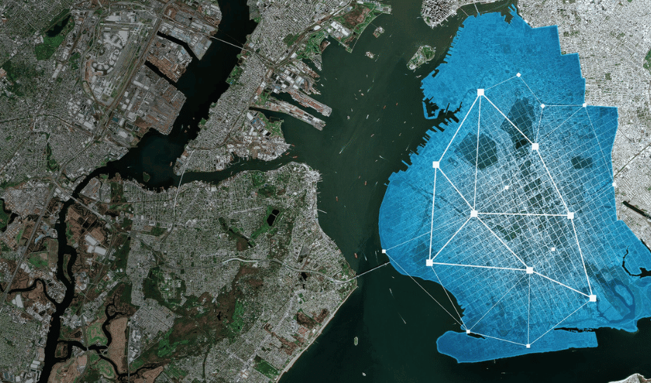
It also uses a smartphone-based app mounted on vehicles to capture geotagged videos and data related to location, distance, and time, as part of road surveys. It obtains footage from dashcams, survey vehicles, and drones too. RoadVision AI's colour-coded dashboard to interpret road infrastructure conditions
Data processing and insights
The video footage and sensor data is then automatically uploaded and processed in the cloud to generate real-time insights on road defects, condition of road furniture (road signs, delineators and pavement markings), safety risks, predictive maintenance, and safety audits.
The system reasons like a road engineer, understanding contexts such as traffic type, road category, and regional maintenance needs, and delivers actionable insights for repair and safety improvements.
Data visualisation
RoadVision AI offers clear, user-friendly road condition maps, similar to Google Maps. Road conditions are categorised into good, average, or requiring urgent attention, based on the satellite imagery.
These maps are tailored for infrastructure management—to be used by road authorities, municipal bodies, smart city administrators, and highway operators—to support maintenance and safety efforts. Road assessment
Business model and impact
RoadVision AI operates on a B2B and B2G SaaS model and offers subscription-based access to its platform. It charges about Rs 1,000 per kilometre for data processing.
Subscription offers features such as road condition maps, safety audit visuals, and predictive maintenance planning.
Users include state governments, civic bodies, and urban and rural infrastructure agencies.
The platform claims to deliver insights with over 95% accuracy, validated by pilot projects across several countries.
“We’ve done over 20 pilot projects with over 100 kilometres of road surveyed per pilot to ensure that the AI is robust and generalisable across regions and road types,” says Dave, who is also the founder of Indika AI, a data-centric AI solutions firm.
The platform offers a scalable, cost-effective alternative to traditional road inspections, delivering up to 60% savings by automating data capture and analysis through AI—eliminating the need for costly hardware, manual surveys, and fragmented tools, he adds.
“With road networks spanning thousands of kilometres, our pricing is designed to make road inspection and asset management scalable for both government and private sector clients."
Global reach and market presence
Currently, RoadVision AI operates in India, Saudi Arabia, Australia, and the United Kingdom. It has partnered with organisations such as SaveLIFE Foundation to enhance road safety management.
In India, the startup has completed pilot projects in Jaipur, Raipur, and Gandhinagar. It is currently working with five state governments and several civic bodies including Raipur Municipal Corporation and Jalandhar Smart City, Punjab.
RoadVision projects an annual revenue of $2.5 million in FY24, with 25-30% coming from the Indian market. Going forward, it plans to expand into Latin America.
Dave says the startup has a “robust project pipeline” in Latin America with over 100 leads.
RoadVision’s competitors in India include Nayan AI, RoadMatrics, Hanu.ai, iRaste, Aarav Unmanned Systems, and Staqu.
Commenting on what differentiates RoadVision, Dave says, “Most competitors only focus on identifying defects. What sets us apart is our end-to-end automation—from data capture using advanced vision systems to AI-driven diagnostics and actionable insights, tailored for real-world deployment by road authorities.”
Going forward, RoadVision AI plans to enhance real-time road monitoring by integrating satellite data and IoT sensors. It is also exploring other applications in road planning, design, and safety improvement.
“We are actively working on integrating satellite data and IoT sensors for real-time road condition monitoring, which will allow for even more precise and proactive road management," says Dave.
Edited by Swetha Kannan